
Built to spec
Built to your engineered drawings, survey, and the real site conditions, not a one-size-fits-all approach forced to fit.
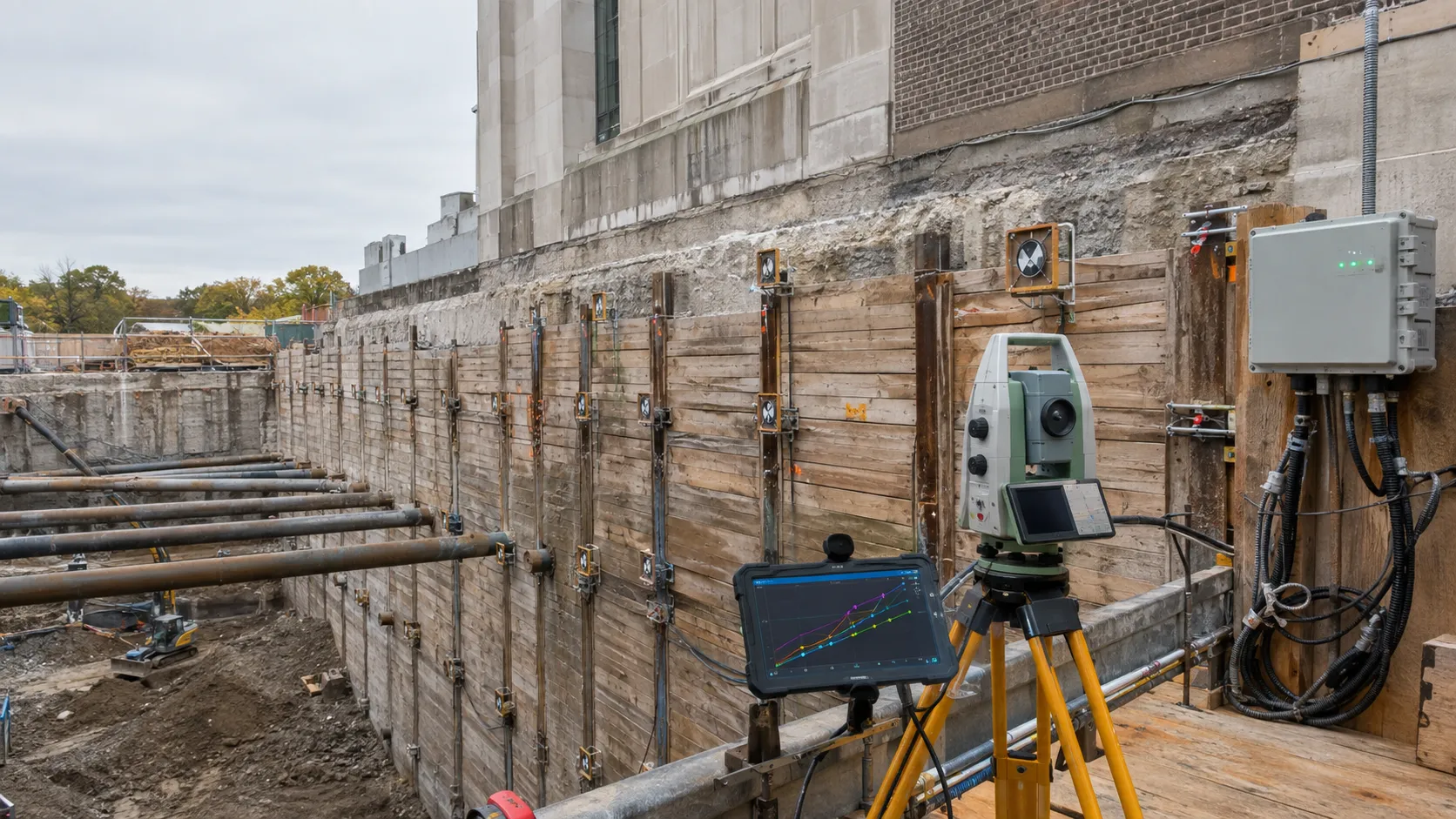
Harrowgate Group directly completes shoring monitoring and instrumentation for developers, engineers, municipalities, and owners of sensitive assets across Toronto, the GTA, and Ontario, coordinating engineered temporary works, site execution, testing, records, and the permanent construction sequence.
Tell us what you need and we’ll get you a quote. Licensed, insured & WSIB-covered · Free, no-obligation quote & on-site assessment.
Licensed, insured & WSIB-covered · Free, no-obligation quote & on-site assessment.
Built to your engineered drawings, survey, and the real site conditions, not a one-size-fits-all approach forced to fit.
Durable materials and methods chosen for the load, traffic, and environment on site.
Send specs, drawings, or photos and get a free, no-obligation site visit and estimate with no guesswork.
Installation and site work completed in accordance with Ontario requirements.
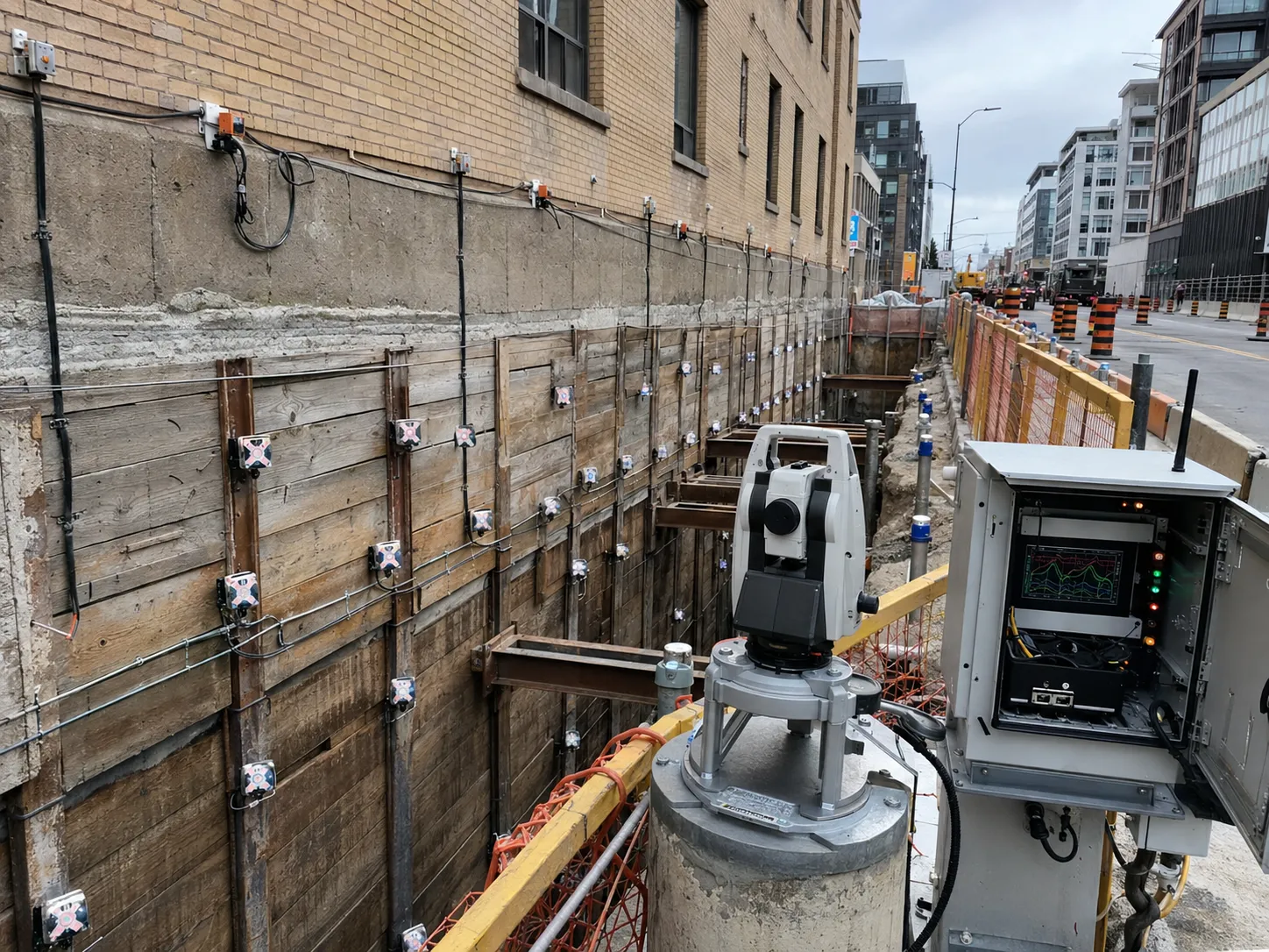
Shoring monitoring measures wall movement, settlement, vibration, brace load, and groundwater response so an excavation can be managed against defined review and action levels. Harrowgate installs, protects, reads, and coordinates instrumentation for commercial and heavy-civil work across Toronto and the GTA, linking results to excavation stages and field observations.
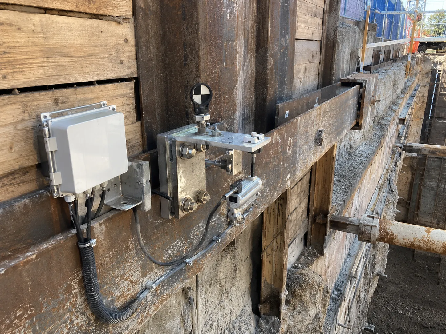
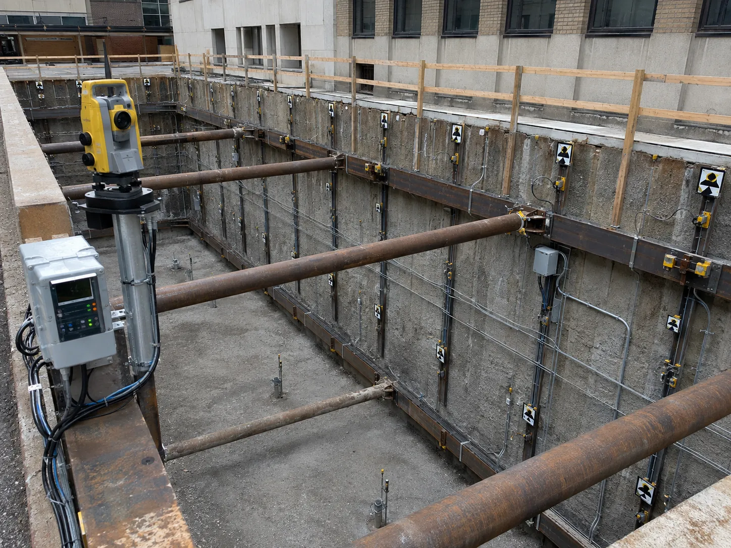
A reliable installation follows the engineered temporary works sequence exactly, because support that is correct in its final configuration can still move or fail during an intermediate stage. We establish controls, install from stable ground, limit exposed soil, activate each support level on time, document concealed work, and release the next excavation stage only after the required checks.
We review the monitoring plan against actual site access and construction sequence before installing instruments. Survey monuments are set outside the expected influence area. Wall targets and inclinometers are positioned to capture critical deflection shapes. Settlement points, crack gauges, piezometers, vibration monitors, and load cells are added where the protected asset or design requires them.
Baseline readings are taken before piling, dewatering, or excavation. We then collect readings at the specified frequency and at event-based milestones such as pile installation, anchor stressing, each excavation lift, brace pre-load, major rainfall, a shutdown, or support removal. Results are plotted against stage and time, not presented as isolated numbers.
Instrument identification, coordinates, elevation datum, reading method, calibration information, baseline date, and environmental conditions are kept consistent. We protect heads and targets from traffic, frost, concrete splash, and equipment. Damaged or inaccessible instruments are reported immediately because a blank trend is not evidence of stability. Field notes record loading, stockpiles, pumping, vibration sources, observed cracking, seepage, lagging gaps, and unusual events so the engineer can distinguish construction response from measurement noise.
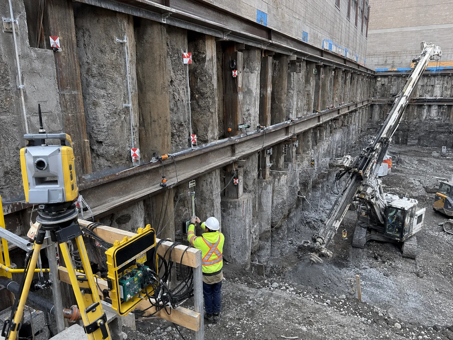
The governing requirements are the sealed project drawings, geotechnical recommendations, Ontario construction regulation, applicable OBC provisions, referenced CSA standards, and any project-specific OPSS clauses. Dimensions and capacities are project values, not rules of thumb. We verify materials, geometry, testing, installation tolerances, temporary loading, groundwater assumptions, inspection points, and removal requirements before affected work is covered.
The engineer sets instrument type, location, accuracy, baseline period, frequency, reporting, review level, action level, and response protocol. Survey accuracy must suit the movement tolerance, while inclinometer casing alignment and embedment must capture the stable reference assumed by the design.
Piezometer range and tip elevation match the water-bearing unit. Vibration equipment is selected for the project criteria and mounted to the monitored asset correctly. Ontario construction requirements for adjacent structures, sealed support designs, OBC provisions, and project specifications establish the control framework. Calibration certificates and raw data remain traceable.
Ontario construction requirements also call for accurate service location before excavation, written precautions from an engineer where adjacent stability may be affected, and a clear area at least 1 metre from the upper edge for equipment, spoil, rock, and materials. The support and site controls are adjusted when actual soil or water differs from the design assumptions.
The failures buyers worry about are excessive wall movement, settlement outside the cut, water inflow, ground loss, damaged utilities, failed inspections, and schedule delays caused by an unbuildable sequence. Prevention depends on observing small deviations early. We compare the work with drawings, logs, surveys, test results, groundwater behaviour, and monitoring trends before a deviation becomes a structural or property problem.
Monitoring fails when baselines are taken after disturbance begins, reference points move with the excavation, readings use inconsistent equipment, instruments are placed outside the likely movement zone, or alerts wait for a weekly report. Another failure is treating a threshold as permission to continue until the number is exceeded.
We prevent these problems with early installation, redundant references, automated alerts where appropriate, same-method readings, rapid validation of outliers, and a clear communication tree. Movement rate and trend can require action even when the absolute value remains below the limit.
Daily coordination covers weather, water, instrument access, loading near the crest, housekeeping, safe entry, and changes by other crews. When a hold point or action level is reached, the affected stage stops. We stabilize the work, verify the observation, involve the engineer, and document the accepted response before continuing.
Have drawings for shoring monitoring and instrumentation? Send them over and we will scope it.
We plan shoring monitoring and instrumentation from the geotechnical information, sealed drawings, excavation or installation sequence, access, nearby assets, groundwater, testing, and the permanent works interface. Instrument identification, coordinates, elevation datum, reading method, calibration information, baseline date, and environmental conditions are kept consistent. The field plan assigns hold points and makes any changed condition visible before the next stage proceeds.
An engineer-designed system is required when the selected support type, depth, width, soil, water, surcharge, adjacent asset, or project condition falls outside a permitted prescriptive arrangement. Ontario rules also require project-specific engineering for trenches deeper than 6 metres or wider than 3.6 metres. The sealed drawings must remain available and field variations need written review.
We need the latest excavation and structural drawings, geotechnical report, survey, utility information, groundwater data, adjacent foundation details, access limits, property constraints, loading plan, and proposed sequence. For sensitive sites, monitoring requirements and baseline condition records must also be established. Missing information is resolved before it becomes a drilled obstruction or unsupported field condition.
Movement control combines a suitably stiff support system, short excavation stages, timely anchors or braces, groundwater management, controlled surcharge, close soil contact, and monitoring. Where the existing footing lies inside the influence zone, underpinning may transfer its load deeper. Survey and instrument trigger levels provide the decision points for holding, stabilizing, or revising the sequence.
We record the location and nature of the difference, protect the excavation in its current stable stage, and notify the engineer. Changes in soil, groundwater, obstructions, footing geometry, or grout response can alter capacity and movement. Work resumes in the affected area only after the design is confirmed or revised for the actual condition.
Groundwater is managed to the geotechnical and shoring design without causing piping, base instability, erosion, or settlement outside the excavation. Measures may include sumps, filtered wells, wellpoints, cut-off walls, drainage layers, staged pumping, and piezometers. Discharge routes, treatment, permits, standby capacity, and response to power loss are planned before pumping begins.
Often yes, provided the engineered staging, protection, access, traffic control, vibration limits, emergency routes, and monitoring plan support continued operations. We divide the site into controlled work zones and coordinate disruptive activities around operating constraints. The feasibility depends on available clearance, public exposure, utility continuity, equipment movements, and the owner's tolerance for noise and vibration.
Closeout records can include layout surveys, installation logs, material tickets, concrete or grout results, anchor or nail tests, weld and connection records where specified, inspection reports, monitoring plots, field changes, photographs, cut-off elevations, abandoned element locations, and removal records. The exact package follows the project specification and gives the owner a traceable account of concealed temporary works.
Still have a question about shoring monitoring and instrumentation? Ask our team directly.
Commercial and heavy-civil construction delivered for developers, contractors, property managers, and municipalities.
Send drawings, a site plan, or a description of the scope. Harrowgate Group is licensed, insured, and WSIB-covered.
Licensed, Insured & WSIB-Covered, work managed and documented on every job
Tell us what you need and we’ll get you a quote. Licensed, insured & WSIB-covered · Free, no-obligation quote & on-site assessment.
Harrowgate Group provides shoring monitoring and instrumentation, delivered and installed with quote-ready support across Toronto and surrounding Ontario communities.
Companies We've Worked With
Harrowgate Group delivers commercial and heavy-civil construction for developers, contractors, institutions, municipalities, and property groups across Ontario.
 Popeyes
  Tim Hortons
  Subway
  University of Toronto
  Madison Group
  RioCan
  Women's College Hospital
  Starbucks
  Mazda
Mazda  TD Bank
  City of Toronto Popeyes Tim Hortons Subway University of Toronto Madison Group RioCan Women's College Hospital Starbucks Mazda TD Bank City of Toronto
 Three fields. We reply with the next step.
Thanks, we will call you shortly.